My name is MAKO
Based in Sapporo, Hokkaido | Born and raised in Obihiro, Hokkaido | Lover of Sapporo Classic beer and fresh sashimi | Passionate about road trips and camping | Always chasing beautiful scenery
Why Is It Called Cape Chikyu?The Short Answer
Cape Chikyu was not named because you can see the curve of the Earth.
Its name is connected to an older Ainu place-name describing the dramatic cliffs. Muroran’s tourism information traces “Chikyu” to an Ainu word meaning “cliff,” while the city’s cultural heritage records the place-name Poro Chikewe, meaning roughly “parent cliff.” Over time, the sound came to be written with the Japanese characters for chikyu—“Earth.”

Why You Should Care
When Japanese travelers hear the name Chikyu Misaki, they immediately notice something unusual.
Chikyu means Earth.
And from the observation deck, the Pacific horizon appears to form a gentle arc, giving visitors a strong sense of the planet’s vast scale. Hokkaido’s official tourism site even promotes Cape Chikyu as a place where you can “feel the Earth’s curve.”
So it would be easy to assume:
“It must be called Earth Cape because the Earth looks round from here.”
But the name came first.
That coincidence between an old Ainu-derived place-name and the enormous ocean view is what makes Cape Chikyu so memorable.
The Story Behind It
Does “Cape Chikyu” Really Mean “Earth Cape”?
In modern Japanese, yes.
The characters 地球 mean “Earth.”
But that was not the original meaning of the place-name.
The Muroran Tourism Association explains that the name is commonly traced to the Ainu word Chikep, meaning “cliff.” The pronunciation later changed through forms such as Chikiu before being written as the Japanese word Chikyu.
Muroran City’s cultural heritage records provide an even more detailed local name:
Poro Chikewe — “parent cliff.”
So the original name was describing what people saw here long before modern tourism:
the cliffs.
Not the Earth.
Why Are the Cliffs Such an Important Part of Cape Chikyu?
Cape Chikyu sits on the outer coast of Muroran’s Etomo Peninsula.
Around the cape, cliffs roughly 100 meters high rise directly above the Pacific Ocean. From the observation area, visitors look down from around 130 meters above sea level.
This dramatic coastline is not just beautiful.
It also helps explain why Ainu place-names in this area often describe specific landforms.
At Cape Chikyu, the cliff was important enough to become part of the name itself.
Standing there today, with waves crashing far below, it is easy to understand why.
Why Does the Horizon Look So Round?
The observation deck has an unusually open view.
There are almost no large landforms blocking the Pacific Ocean in front of you.
From around 130 meters above sea level, the horizon stretches across an enormous field of view and appears as a gentle arc. On clear days, distant landforms such as Hokkaido Komagatake and the Shimokita Peninsula may also be visible.
That broad panorama creates the feeling that you are looking at the shape of the planet itself.
So while the view did not give Cape Chikyu its name, it has made the modern Japanese name feel strangely perfect.
That is one of the best “Why Hokkaido” coincidences in Muroran.
What Is the White Lighthouse Below Cape Chikyu?
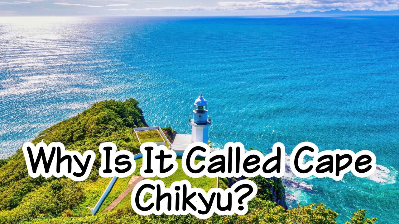
Look down from the observation deck and you will see a bright white lighthouse standing above the sea.
This is Chikiu Misaki Lighthouse.
It was first lit on April 1, 1920 and stands on the cliffs about 130 meters above sea level. The Muroran Tourism Association notes that its light reaches roughly 44 kilometers out to sea.
Its appearance is also unusual.
Many Japanese lighthouses use contrasting colors to remain visible against winter snow. Chikiu Misaki Lighthouse is almost completely white and has an octagonal lower structure.
The lighthouse is normally not open for visitors to enter, although special public openings may occasionally take place, including around Marine Day.
Why Is Cape Chikyu Connected to Ainu Cultural Heritage?
Cape Chikyu is more than a viewpoint.
It is also part of the nationally designated scenic area called Pirika Noka – Outer Coast of the Etomo Peninsula.
Muroran City explains that this protected landscape includes four places where Ainu place-names and the physical features behind those names remain clearly connected. Cape Chikyu is one of them.
Pirika noka can be understood as “beautiful form” in Ainu.
The designation recognizes landscapes where nature, language, stories, and Ainu cultural memory are closely connected.
So when you look at Cape Chikyu’s cliffs, you are not only seeing beautiful geology.
You are also seeing a landscape whose shape has been remembered through language for generations.
Why Is the Lighthouse View So Different From Muroran’s Industrial Image?
Muroran is famous as one of Hokkaido’s major industrial and port cities.
Factories surround parts of Muroran Port, and the city is also well known for its dramatic factory night views.
But cross to the Pacific side of the peninsula and the scenery changes completely.
Factories disappear.
Cliffs rise above the ocean.
Wind comes directly from the Pacific.
And the horizon seems almost endless.
That contrast is part of what makes Muroran fascinating.
One city contains both heavy industry and wild coastal nature.
What Else Might You See at Cape Chikyu?
Cape Chikyu is also known as a habitat for peregrine falcons.
Hokkaido’s official tourism site notes that falcons can often be seen nesting and hunting around the cliffs. Dolphins and whales may also occasionally be spotted offshore between spring and autumn.
You should not visit expecting wildlife every time.
But bring binoculars if you have them.
Even without animals, the cliffs, lighthouse, and huge Pacific horizon are more than enough reason to stop.
The Historic Lighthouse That Watches Over Cape Chikyu
Cape Chikyu is famous for its spectacular ocean views, but don’t forget to look at the white lighthouse standing proudly on the cape.
It has guided ships safely along Hokkaido’s southern coast for more than a century.
A Lighthouse with More Than 100 Years of History
The Cape Chikyu Lighthouse was first lit on April 1, 1920.
For over 100 years, it has continued to guide ships traveling through the surrounding waters and remains an important landmark for both sailors and visitors.
The lighthouse has also been selected as one of Japan’s “50 Best Lighthouses,” recognizing its historical significance and beautiful setting overlooking the Pacific Ocean.
Today, the lighthouse has become one of Cape Chikyu’s most recognizable symbols, standing against the blue sea and sky.
Did You Know?
- Cape Chikyu was not named because the Earth looks round; its name developed from an Ainu place-name connected with cliffs.
- The cliffs around the cape are roughly 100 meters high.
- Chikiu Misaki Lighthouse was first lit in 1920.
- Cape Chikyu is included in the nationally designated scenic area Pirika Noka – Outer Coast of the Etomo Peninsula.
- Cape Chikyu is also known as a nesting area for peregrine falcons.
FAQ
Does Cape Chikyu Mean “Earth Cape”?
In modern Japanese, the characters 地球 do mean “Earth.”
However, the place-name is connected to older Ainu words describing the cliffs, rather than being originally named after planet Earth.
Can You Really See the Curve of the Earth?
From the high observation deck, the very wide Pacific horizon appears as a gentle arc and creates a strong impression of the Earth’s roundness.
The official Hokkaido tourism site highlights this as one of Cape Chikyu’s signature experiences.
Can You Enter Chikiu Misaki Lighthouse?
Normally, no.
The lighthouse is generally closed to the public, although special opening events may occasionally be held.
Is Cape Chikyu Worth Visiting on a Cloudy Day?
The ocean and cliffs can still be impressive, but clear weather gives you the best chance of seeing the broad horizon and distant landforms.
If the cape is your main goal, checking the weather before visiting is worthwhile.
Visit It Yourself
Location
Cape Chikyu Observation Deck
Bokoi Minamimachi 4-chome, Muroran, Hokkaido.
Best Season
May–October is the most comfortable period for walking and enjoying the view.
Cape Chikyu can be visited in other seasons as well, and it is especially popular on New Year’s Day for the first sunrise of the year.
How to Get There
From JR Bokoi Station, it is about 35 minutes on foot.
By bus, get off at Chikyu Misaki Danchi and walk about 15 minutes.
From Muroran IC, the drive takes about 35 minutes.
Estimated Visit Time
30–60 minutes
Allow longer if you want to walk around the surrounding green space and trails.
Admission Fee
The official city information does not list an admission fee for the observation deck.
However, the parking lot became paid on April 1, 2026:
- Motorcycle: ¥200
- Standard passenger car: ¥500
- Bus: ¥2,000
Please check the official website for the latest information.
Official Website
Muroran Tourism Association – Cape Chikyu
Final Thoughts
Why is it called Cape Chikyu?
Not because someone stood here, saw the round horizon, and named it “Earth.”
The story is older than that.
Long before modern sightseeing, people described this place through its most powerful feature:
the cliffs.
That Ainu place-name changed over time.
Its sound eventually became Chikyu.
And by coincidence, chikyu also means Earth in Japanese.
Then there is the view.
A huge Pacific horizon.
A white lighthouse.
Cliffs falling straight into the sea.
And a landscape so open that you really do feel the scale of the planet.
Sometimes a place-name and a landscape come together almost perfectly.
Cape Chikyu is one of those places.
So when you stand at the observation deck, do not only look toward the horizon.
Look down at the cliffs too.
That is where the real story of the name begins.








コメント