
My name is MAKO
Based in Sapporo, Hokkaido | Born and raised in Obihiro, Hokkaido | Lover of Sapporo Classic beer and fresh sashimi | Passionate about road trips and camping | Always chasing beautiful scenery
Why Does Wakkanai Have a Roman-Looking Breakwater?The Short Answer
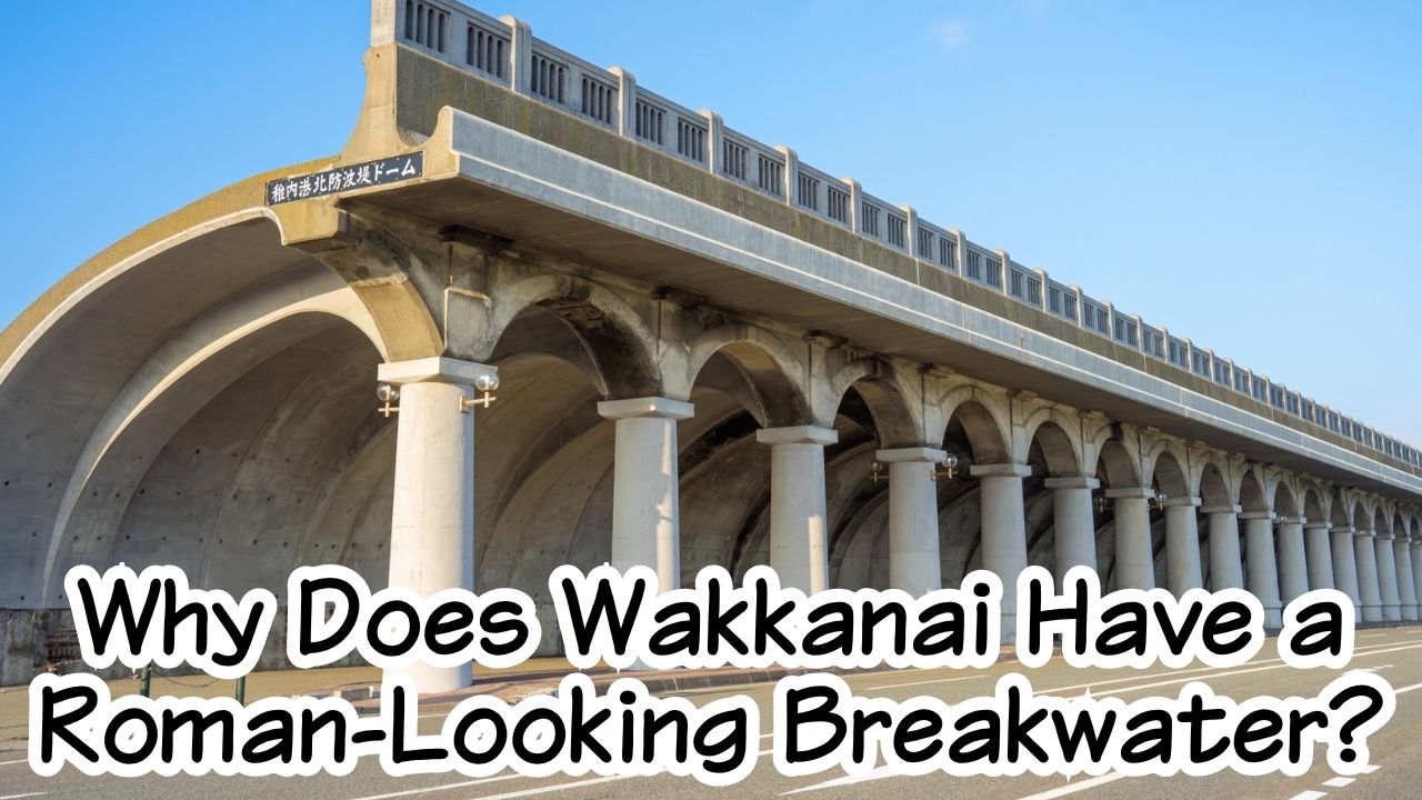
The Wakkanai Port North Breakwater Dome was built from 1931 to 1936 to protect people, railways, and cargo from the powerful wind and waves that swept over Wakkanai Port. It measures 427 meters long, stands about 13.6 meters high, and has 70 columns supporting its distinctive half-arch roof.
Its Roman-looking appearance was influenced partly by young engineer Minoru Tsuchiya’s studies of Greek and Roman architecture. But the unusual form began with a practical engineering problem: how do you stop waves from crashing over a breakwater and onto the people behind it?

Why You Should Care
At first glance, the dome is one of Wakkanai’s best photo spots.
But once you know its story, the columns begin to look different.
This was once part of a transportation gateway connecting rail passengers in Hokkaido with ships crossing the Soya Strait to southern Sakhalin.
Travelers carried luggage through this area.
Trains came close to the port.
Ships waited beyond the sea wall.
And outside, Wakkanai’s wind and waves could be violent enough to knock people into the water.
The Wakkanai Port North Breakwater Dome is therefore not just architecture.
It is a surviving piece of the time when Wakkanai truly was Japan’s northern gateway.
Why Does the Wakkanai Breakwater Look Like a Roman Monument?
The answer is partly beauty.
But first, it was engineering.
Why Was a Normal Breakwater Not Enough?
Wakkanai is one of Japan’s windiest port cities.
Hokkaido’s official tourism site says strong winds blow on around 130 days a year. Before the dome was built, an earlier breakwater about 5.5 meters high could not reliably stop the waves. Water crossed the wall, struck the waterfront, and there were even accidents in which people fell into the sea.
Something taller was needed.
But simply building a huge solid wall would not solve every problem.
In 1931, Wakkanai port office director Toshio Hirao proposed something much more unusual: columns supporting a curved roof-like structure that could catch and redirect waves coming over the wall.
That practical idea created the basic form of the dome.
Was It Really Inspired by Ancient Rome?
To some extent, yes.
But it was not simply a copy of a Roman building.
Hirao developed the basic engineering concept. His younger colleague Minoru Tsuchiya then turned it into a detailed structural design.
Tsuchiya had studied concrete arches at university and still had materials from lectures on Greek and Roman architecture. According to the Japan Society of Civil Engineers, those memories influenced the appearance of the finished structure.
That is why something built to stop North Sea-like waves ended up with such elegant columns and arches.
Function created the dome.
Engineering made it possible.
Architecture gave it character.
Why Did Wakkanai Need Such an Important Port?
To understand the dome, you have to look north.
Across the Soya Strait lies Sakhalin.
How Did Wakkanai Become Japan’s Northern Gateway?
After the Russo-Japanese War, the 1905 Treaty of Portsmouth transferred the southern half of Sakhalin to Japanese control. This greatly increased Wakkanai’s importance as a transportation point facing the island.
Port construction began in earnest in 1920.
Then, in 1923, the government-operated Chihaku ferry route began connecting Wakkanai with Odomari, today’s Korsakov in southern Sakhalin.
Wakkanai was no longer simply a remote northern fishing town.
It became a place where:
railway → port → ship → Sakhalin
all connected.
What Was the Chihaku Ferry?
When the Chihaku route began in 1923, the railway still ended at what is now Minami-Wakkanai Station.
Passengers had to travel about 1.6 kilometers from the station to the ship, even during winter.
The railway was extended to Wakkanai Port in 1928.
Then, in 1938, Wakkanai Pier Station opened directly beside the dome. Passengers could leave the train and transfer toward the ferry while staying protected from much of the rain, wind, and sea spray.
Imagine arriving here nearly 90 years ago.
A train stops beside the harbor.
You step out with your suitcase.
Concrete columns stretch ahead.
Beyond them is the cold sea.
And your next destination is across the Soya Strait.
Who Designed the Wakkanai Port North Breakwater Dome?
One of the most surprising parts of the story is the age of the engineer behind it.
How Did a 26-Year-Old Engineer Help Create It?
Minoru Tsuchiya had graduated from university only a few years earlier when he was given the job.
He was just 26 years old.
In January 1931, Hirao instructed Tsuchiya to produce the design in time for construction to begin that April. Tsuchiya completed the detailed design calculations in only about two months.
That was an extraordinary challenge.
There was no standard Japanese design manual for a giant roofed breakwater like this.
Tsuchiya later recalled that the project forced him to rely on what he knew about concrete arches, structural calculation, and architecture.
Was Minoru Tsuchiya the Only Designer?
Not really.
Tsuchiya is usually named as the designer, including by Wakkanai City.
But Tsuchiya himself later stressed that the dome should be considered a collaboration between himself and Toshio Hirao.
Hirao proposed the basic concept.
Tsuchiya calculated and developed the detailed structure.
Hirao then helped push the unusual plan through the authorities.
It is a wonderful reminder that famous architecture is often not the work of one person alone.
Why Did Construction Take Five Years?
Designing it was difficult.
Building it beside the northern sea was even harder.
Construction ran from 1931 to 1936. Winter cold, strong winds, high waves, and the limits of port-construction technology at the time made the work extremely demanding. Wakkanai City notes that one caisson knocked down by waves during construction still remains buried beneath the water.
The finished structure stretched:
- 427 meters
- about 13.6 meters high
- with 70 concrete columns.
It was infrastructure built on a huge scale for a very real northern problem.
What Happened to the Dome After the Sakhalin Route Ended?
The dome’s busiest first chapter did not last forever.
History changed around it.
Why Did the Chihaku Ferry Route End?
The ferry connection ended in 1945 as World War II came to an end.
Wakkanai City records that the final ship from Odomari arrived there on August 23, 1945, carrying people evacuating from southern Sakhalin.
The transportation system that had given the dome much of its original purpose disappeared.
Later, the structure was used in other ways, including for port storage and connections with routes to Rishiri and Rebun.
But the columns remained.
Was the North Breakwater Dome Almost Demolished?
Yes.
By the 1970s, decades of salt, wind, and weather had badly damaged the concrete.
Pieces began peeling and falling, and demolition became a serious possibility.
But by then, people in Wakkanai no longer saw the dome as only an old piece of infrastructure.
It had become part of the city’s identity.
Local calls for preservation grew stronger.
An investigation found that the foundations were still in good condition, so Wakkanai chose restoration rather than disappearance.
Is Today’s Dome Completely Original?
Not entirely.
From 1978 to 1980, the dome underwent a major reconstruction.
The sound foundation was retained, while the deteriorated upper structure was extensively rebuilt in a way that preserved the original form.
That distinction matters.
The structure you see today carries the design and foundations of the 1930s, but it has also survived because later generations deliberately chose to rebuild and preserve it.
Why Is the North Breakwater Dome Still Important Today?
Today, there are no railway passengers walking through the dome to board a ship for Odomari.
But the structure is far from forgotten.
Why Is It a Hokkaido Heritage Site?
The North Breakwater Dome was selected as Hokkaido Heritage in 2001 and as a Japan Society of Civil Engineers Heritage Site in 2003.
The reason is not just its appearance.
It represents an unusual engineering solution, the development of Wakkanai Port, and the history of transportation between Hokkaido and Sakhalin.
It is both a technical achievement and a historical memory.
What Is the Dome Used for Now?
Today, the surrounding North Breakwater Dome Park is used for concerts, community events, illumination, running events, and other activities. It is also one of Wakkanai’s best-known filming and photography locations.
In 2026, the dome celebrated the 90th anniversary of its 1936 completion. Wakkanai held concerts, exhibitions, lectures, and other commemorative events to revisit its history and engineering value.
A structure built to stop waves has become a place where people gather.
That may be the most successful kind of preservation.
My Recommendation: Explore Cape Soya and the White Road Too!
If you’re visiting Wakkanai’s famous North Breakwater Dome, I highly recommend exploring Cape Soya and the White Road as well!
Both are wonderful destinations for a scenic drive and offer completely different views of northern Hokkaido.
Cape Soya is famous as Japan’s northernmost point on its main islands, while the White Road is known for its beautiful scallop-shell-covered surface and breathtaking coastal scenery.
Combining these three spots is one of my favorite ways to experience the unique beauty of Wakkanai!
Why Do People Love Cape Soya?
What makes Japan’s northernmost point such a special place?
Discover the story behind Cape Soya and why travelers love visiting this remote corner of Hokkaido.
Read next: Why Do People Love Cape Soya? The Story Behind Japan’s Northernmost Point

Why Is Wakkanai’s White Road Made of Scallop Shells?
Why is this scenic road covered with crushed scallop shells instead of ordinary pavement?
Discover the fascinating story behind one of Wakkanai’s most unusual landscapes!
Read next: Why Is Wakkanai’s White Road Made of Scallop Shells? The Story Behind Hokkaido’s Northernmost Scenic Road

Did You Know?
- Construction began in 1931 and the dome was completed in 1936.
- It is 427 meters long and has 70 columns.
- Designer Minoru Tsuchiya was only 26 years old when he worked on the project.
- Wakkanai Pier Station opened beside the dome in 1938, allowing passengers to transfer more easily between train and ship.
- The dome was almost lost to deterioration before being extensively restored from 1978 to 1980.
FAQ
Is the Wakkanai North Breakwater Dome Really a Roman Building?
No.
It is a Japanese reinforced-concrete port structure built in the 1930s.
However, designer Minoru Tsuchiya had studied Greek and Roman architecture, and those influences can be seen in the columns and arches.
Why Is It Called a “Dome” If It Is Open on One Side?
The word refers to the large curved roof-like structure that shelters the waterfront side of the breakwater.
Its semi-arched form was designed to control waves and spray while leaving a covered passage beneath it.
Can You Walk Inside the Dome?
Yes.
Visitors can walk along the columned passage and experience its scale from inside. It is a public landmark and event space beside Wakkanai Port.
Is the Dome Still Used as a Breakwater?
Yes.
Hokkaido Heritage states that it is not simply a preserved monument; it still functions as part of Wakkanai’s breakwater infrastructure.
Is Sakhalin Visible From the Dome?
The dome itself is in central Wakkanai rather than at a high viewpoint, so it is not the best place to look for Sakhalin.
For wide views across the Soya Strait, Cape Soya and elevated viewpoints around Wakkanai are better choices.
Visit It Yourself
Location
Wakkanai Port North Breakwater Dome
Kaiun, Wakkanai, Hokkaido
Wakkanai City also lists the site as Kaiun 1-chome 2-2.
Best Season
Year-round
Summer is the easiest season for walking around Wakkanai.
Winter gives the dome a much harsher atmosphere and makes it easier to understand why protection from wind and sea spray mattered so much.
Whatever the season, remember that Wakkanai is known for powerful wind.
How to Get There
From JR Wakkanai Station: about 5 minutes on foot
From Wakkanai Airport: about 30 minutes by car.
Because it is so close to the station, this is one of the easiest Wakkanai landmarks to visit without a rental car.
Estimated Visit Time
Quick visit: 20–30 minutes
Photography + slow walk: 45–60 minutes
If you are interested in the Sakhalin connection, consider combining it with the Wakkanai Karafuto Memorial Museum to better understand the history behind the port. Wakkanai City specifically introduces the museum together with the dome for visitors exploring this history.
Admission Fee
Free to visit the public dome area.
Special events may have their own arrangements.
Best Photo Spots
Try three views:
- Stand near one end and photograph the columns disappearing into the distance.
- Move close to a column and shoot upward to emphasize the curved roof.
- Visit around sunset or during a scheduled illumination for a completely different atmosphere.
Do not climb onto the structure.
Official Website
Please check the official website for the latest information.
Final Thoughts
Why does Wakkanai have a breakwater that looks like an ancient Roman monument?
Because Wakkanai had a problem.
Wind.
Waves.
And a busy waterfront filled with people trying to reach trains and ships.
A normal seawall was not enough.
So engineers tried something unusual.
Toshio Hirao imagined a curved shelter.
A 26-year-old Minoru Tsuchiya turned the idea into calculations and concrete.
Seventy columns rose beside the sea.
Behind them came railway tracks.
Beyond them waited ships bound for Sakhalin.
Then history changed.
The ferry disappeared.
The railway platform disappeared.
The concrete aged.
For a time, even the dome itself might have disappeared.
But Wakkanai chose to keep it.
And in 2026, 90 years after completion, those columns are still standing beside the northern sea. 稚内市
Today, most travelers first notice how beautiful it is.
But beauty was never the whole point.
Wakkanai’s North Breakwater Dome is more than a beautiful row of columns.
It is a monument to the wind, waves, railways, ships, and travelers that once made Wakkanai Japan’s northern gateway.









コメント